
How GPS Enhances Reusable Packaging Visibility
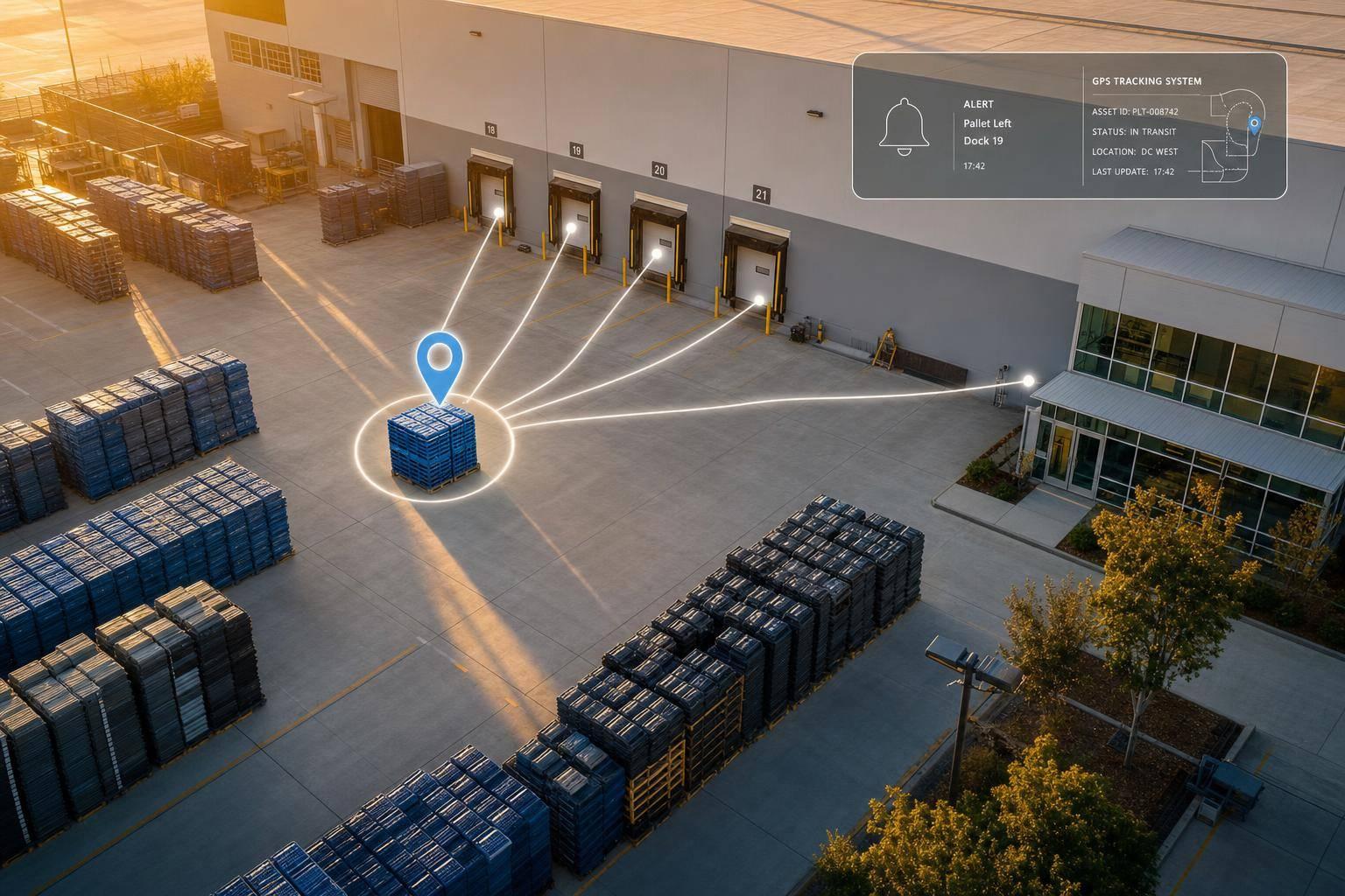
If you don’t know where your returnable totes, pallets, racks, and bins are, you’re likely losing money every year. In many fleets, untracked reusable packaging loses 5% to 15% per year. GPS helps by showing where each asset is, how long it stays at a site, and when it moves outside the expected path.
Here’s the short version:
- GPS fills the gap between scans
- It cuts loss and replacement spend
- It shows long dwell times at customer and supplier sites
- It helps teams get assets back into circulation faster
- It can push shrinkage below 2%
- Some programs report up to 18x first-year ROI
Put simply: I’d use GPS to turn reusable packaging from a blind spot into a tracked asset pool. That means fewer missing assets, fewer disputes, and better use of the fleet you already own.
A few numbers make the case fast:
- Annual loss rates for untracked fleets: 5% to 15%
- Example loss on 10,000 containers at $200 to $300 each: $650,000 to $3,450,000
- Cycle-time gain from better tracking: 10%, which can free up the same amount of fleet capacity
- Tracked RTP programs can bring shrinkage to below 2%
What GPS does best is simple: it shows location between handoffs, flags late returns with geofences, and gives you dwell and cycle-time data you can use in your WMS and ERP. If I were rolling it out, I’d start with high-cost assets and high-loss routes first.
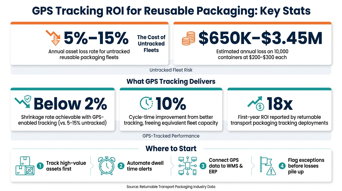
GPS Tracking ROI for Reusable Packaging: Key Stats
Red Sofa: Magna's Bridget Grewal on returnable packaging, phytosanitary risks and advanced tracking
sbb-itb-eafa320
The core problems GPS solves for reusable packaging
When reusable packaging doesn't have asset-level tracking, the math starts working against you. Shrinkage, slow returns, and idle time eat into ROI. And those visibility gaps usually show up in three expensive ways: loss, slow returns, and too much dwell time.
The biggest hit is shrinkage.
Loss, shrinkage, and replacement costs add up quickly
Untracked returnable packaging tends to disappear little by little, with annual loss rates usually falling between 5% and 15%. For a fleet of 10,000 containers that cost $200 to $300 each, that level of annual loss can add up to $650,000 to $3,450,000 before you even count labor or disruption.
That kind of loss usually doesn't come from one dramatic event. It's more like a slow leak. A container goes missing here, another one there, and over time the cost gets baked into day-to-day operations. Teams end up covering it with replacement purchases, overtime, and production delays instead of fixing the root issue.
GPS changes that. It turns a hidden cost into a tracked exception.
Transit blind spots slow down returns and exception handling
Truck-level tracking can tell you where the shipment is. It can't tell you where each tote or pallet is.
That gap creates two direct problems. Returns take longer because teams have less information to recover missing assets. And when something goes wrong, there isn't enough data to show where the delay happened.
That's when finger-pointing starts. Disputes between partners can drag on because neither side has proof. Without asset-level GPS, exception handling is slower and less exact. Asset-level GPS gives teams a clearer way to spot what happened and where it happened, which is why it does more here than shipment-level tracking.
Long dwell times reduce turns and force excess inventory
Even when assets aren't lost, they can still drain the program quietly. If packaging sits idle at a customer or supplier site long after its return window, it can't be used for the next cycle. That's capital tied up and unavailable for work.
Without dwell data, teams can't flag stalled assets before delays pile up. So what happens next? They buy more packaging to fill the gap. That ties up working capital and pushes fleet size higher than it needs to be.
A 10% improvement in cycle time from better tracking can effectively expand fleet capacity by 10% without buying a single new unit. The same data also helps teams see where GPS can improve turns and utilization.
How GPS improves reusable packaging visibility
GPS fills the blind spot between dock scans and handoffs, so reusable packaging stays visible while it's moving and while it's sitting at third-party sites. It starts with live location data.
Real-time location data creates end-to-end asset visibility
GPS-enabled trackers record movement history, loading and unloading events, in-transit progress, and the last known location. That turns reusable packaging into a live asset pool instead of a box you only see when someone scans it.
This is a big deal across long U.S. distribution lanes. A reusable tote moving between a fulfillment center and a retailer may pass through several handoffs before anyone sees it again. GPS keeps visibility going between those handoffs, logging and timestamping the full trip from start to finish.
Many systems also pair GPS with BLE, Wi-Fi, or UWB indoors, so visibility doesn't stop at the warehouse door or in the yard. BLE tags can use existing smartphones, vehicle hubs, and forklifts as relays, which cuts down the need for fixed readers at every site.
Once teams have live location data, they can add geofencing and automated alerts.
Geofencing and alerts help teams act before assets go missing
Geofencing lets you place a virtual boundary around a supplier site, customer dock, or regional distribution center. When an asset enters or leaves that area, the system can trigger an alert. Your team knows when a container arrives, when it leaves, and, just as important, when it stays past its return window.
Instead of finding out weeks later during reconciliation that an asset is missing, the system flags the issue while there's still time to do something about it. Route deviations and unplanned stops can trigger alerts too. No one has to keep checking a spreadsheet by hand. The result is less manual follow-up and a cleaner, data-based way to handle exceptions.
The same location stream also shows how long assets stay at each stop.
Dwell and cycle-time data improve asset utilization
GPS doesn't only show where assets are. It shows how long they've been there. Dwell time data tells you which sites are holding containers past their return windows and for how long. That's the kind of detail a spreadsheet usually misses.
When operations teams can see that a site keeps holding totes beyond the agreed window, they can address it with facts, not guesswork. Tracked dwell data gives teams proof they can use to enforce return windows and cut idle time. And when assets come back faster, you get better asset use, shorter cycle times, and more capacity from the fleet you already have.
How to apply GPS tracking in a 3PL and fulfillment network
Start with high-value assets and high-risk routes
Begin with high-value assets like custom racks, stillages, IBCs, and engineered totes. These items cost enough that even a small drop in shrinkage can pay for the program fast.
It also makes sense to focus early on supplier yards and third-party distribution centers. Assets that sit past agreed return windows often pile up there and lock up capital. A targeted rollout across these assets and sites gives teams faster visibility than trying to track the whole network on day one.
Once you’ve mapped the first assets and routes, the next step is simple: make sure that data flows into the tools your team already uses every day.
Connect GPS data to transportation, warehouse, and returns workflows
Connect GPS feeds to your WMS and ERP so alerts can trigger replenishment, billing, and recovery tasks. Set return-window thresholds by site, so overdue assets get flagged on their own.
Geofences can also help turn location data into action. If an asset misses its return window, the system can trigger a recovery task right away. And when GPS data feeds one dashboard, operations teams can spot slow-cycling assets across the network and deal with patterns before they turn into losses.
How JIT Transportation can support GPS-enabled packaging visibility
Tracking only helps if your returns and fulfillment teams can act on the alert right away.
JIT Transportation supports GPS-enabled packaging visibility through nationwide distribution, fulfillment, returns management, VMI, and ERP integration. That means tracking alerts can turn into recovery actions.
Conclusion: GPS turns reusable packaging into a trackable asset pool
When tracking is tied to day-to-day operations, reusable packaging stops feeling like a loss risk and starts working like a managed asset pool. That shift matters because reusable packaging only creates value when you know where it is.
GPS helps close that gap. It cuts down in-transit blind spots, brings dwell issues to light sooner, and helps teams move assets through the cycle faster.
Key takeaways for operations and supply chain leaders
GPS supports day-to-day control and helps recover lost dollars. GPS-enabled tracking is pushing shrinkage rates on reusable plastic transport packaging below 2%, compared with historical loss rates of 5% to 15% for untracked fleets. That difference adds up to recovered capital, not just nicer reporting.
For teams putting this into practice, the playbook is pretty clear:
- Track high-value assets first
- Automate dwell alerts
- Connect location data to WMS and ERP
- Flag exceptions before they turn into losses
Tracking deployments for returnable transport packaging are seeing an 18x first-year ROI. Start with the assets that cost the most to lose, connect the data to the systems your team already uses, and use GPS to recover returns before losses pile up.
FAQs
How does GPS differ from barcode scans?
Barcode scans give you manual, point-in-time updates. For example, they log when an item is picked, packed, or received. But there’s a catch: someone has to scan the item at a set location for that update to happen.
GPS works differently. It gives you continuous, real-time tracking while shipments are moving between facilities. So while barcodes confirm where an item was scanned, GPS shows where it is in transit and helps teams watch routes, spot delays, and check arrival times.
Which reusable assets should be tracked first?
Prioritize high-cost or highly specialized reusable assets first, like custom racks, stillages, intermediate bulk containers, totes, and pallets.
These assets are tied closely to production and work-in-process. When you track them well, you can prevent bottlenecks, cut buffer inventory, and avoid emergency repurchasing when assets go missing or sit too long with suppliers.
What does GPS data need to connect with?
GPS data should feed into a central cloud platform so teams can analyze it in real time. From there, it should connect with ERP, WMS, and TMS systems to automate inventory updates, stock changes, and day-to-day decisions from one place.
It can also tie into BLE scanning and IoT sensors. That link helps bridge outdoor location data with pallet-level tracking and more precise indoor visibility.
Related Blog Posts
Related Articles

8 Ways 3PLs Handle Seasonal Workforce Swings

Marketplace API vs EDI for Fulfillment
